The Maps below show a Beachfront Area in Australia – IELTS Academic Writing Task 1
You should spend about 20 minutes on this task.
The Maps below show a beachfront area in Australia between 1950 and today. Summarise the information by selecting and reporting the main features, and make comparisons where relevant.
Write at least 150 words.

Real IELTS Exam Question, Reported On:
| India | 3rd March 2022 |
Practice with Expert IELTS Tutors Online
Apply Code "IELTSXPRESS20" To Get 20% off on IELTS Mock Test
The Maps below show a Beachfront Area in Australia – Sample Answer 1
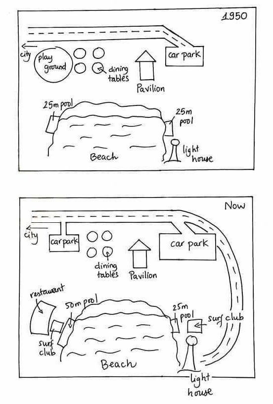
The map details a 1950 Australian beachfront location and alterations in the present day. Looking from an overall perspective, it is readily apparent that there has been an increase in leisure facilities and motor vehicle access to the beach. The beach itself is unchanged.
In 1950, the less developed area contained a road above the beach ending at a car park. Today, the road and car park still exist though both the size of the car park and the length of the road have been extended. The present road leads to a lighthouse (present in 1950 as well) and a newly erected surf club by the side of the beach. A small 25m pool remains in the general vicinity of the lighthouse.
Beneath the road in 1950, there was a playground, an area for dining tables and a pavilion, which are largely unchanged in the present day with the exception of the children’s playground being replaced by an additional car park. Closer to the beach, a 25m pool has been enlarged to 50 meters and there is currently a restaurant and another surf club to the left of the beach.
IELTSXpress
Australian Beachfront Map – Sample Answer 2
The picture gives information about the changes that took place in the beachfront area in Australia from 1950 to at present year. Overall, it can be seen that there is a great development and improvement in facilities across the beach and also at the front side of the area.
To commence with, the road in the front of the beach is very short in the year 1950, but today the road is extended towards the beach, and the car park connected with the road is also enlarged now than it was before. Playground across the road in 1950 is replaced with small car park, and it merges with the road directly that moves towards city.
Furthermore, at the present restaurant is newly develop on the left side of the beach and at one side the pool distance is increased to 50 meters at present then it was before 25 meters in the year 1950, and at another side both pool sizes are same. Two new surf club facilities are added on both sides of the beach, which was not there in the past.
IELTS Writing Task 1 – Australian Beachfront Map
They yielded two maps that demonstrate a beachfront area in 1950 and presently in Australia.
Overall, the major changes are surrounding the beach where clubs and restaurants open now and the new road is made.
In 1950, a car parking road was connected to city road and alongside that road was round shape play ground and dining tables. There was two same dimensions pool, and one was on the east side while another was on the west side of the beach. The pool was 25 meters long. Additionally, one pavilion was between car parking and dining tables, a small lighthouse beside the east pool.
Currently, we can see dramatic changes, primarily in the road. Now the road is not ending at car parking. It developed to the lighthouse, and it’s in u shape. No change for dining tables and pavilion; however, small car parking takes the place of the playground. Another car park area is increased on the southwest side, pool dimensions double than 1950, and open restaurants. One new advancement surf club is the backside of 50m pool, and one is the 25m pool backside.
Also Check: The picture below shows Bell Hill farm in 1976 and 2006


